The Baja Almanac is the Best & Easiest Road Map for Baja
I Used My Baja Almanac Almost Every 15 Minutes While Driving in Baja!
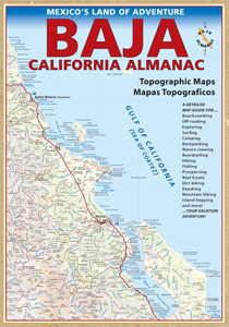
To my knowledge, the Baja California Almanac is the most detailed and easiest to use road map which covers the entire Baja peninsula. It was an invaluable tool for planning my Baja routes and for calculating travel times while on the road.
How it Works
The version I have contains 55 large scale highly detailed maps. In the front of the Almanac, there is a small map of the entire Baja Peninsula, and each region lists the page number to flip to in order to see more detail on that specific region. This allows you to hone in on your target area very quickly by simply flipping to the page number you need.
The Almanac also provides a travel distance chart between the major cities which is in both miles and kilometers.
If you are looking for a no frills easy to use, highly detailed Baja map, The Baja California Almanac is for you.
My only complaint is that I used it so much that the cover ripped off - it was only held on by two center staples. Perhaps future editions can use 3 or 4 staples, what do you say publishers?
Insurance Agents
Adventure Mexican Insurance Services works with over 3,000 insurance agents throughout the US. We are a fully licensed Surplus Lines Broker in most states, and we work as an MGA to provide insurance agents with opportunities to sell our products.
Get AppointedWe accept the following credit or debit cards


Payments by Money Order and Check can also be arranged by calling our office 800.485.4075
Our Partners
& Causes We Support
Surfrider Foundation Retail MemberSolar Power — We've Gone Solar!
Charity Home Building Projects
Passports Required for Land Travel to Mexico
As of June 1, 2009, the US Border Officials are requiring Passports or Pass Cards to cross the border back into the US.
Read More
Adventure Mexican Insurance™ Services
PO Box 1469
Soquel, CA 95073
Phone: 800-485-4075 or
831-477-0599
Email: [email protected]
CA Surplus Lines Broker # OD44414
CA Surplus Lines Broker # OD44414
Copyright © 2001–2026
Adventure Mexican Insurance™ Services
Mexadventure.com ™ Insurance Services
Mexadventure ™ Insurance Services