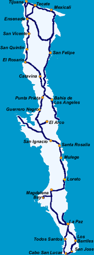
Driving in Baja Distance Table for
the Baja Peninsula
Before driving to Baja, make sure to purchase your Mexican auto insurance policy online from our website!
| Tijuana |
All Distances in MILESTijuana to Tecate = 33 Tecate to Mexicali = 90Mexicali to San Felipe = 121 Ensenada to San Felipe = 152 Tecate to Ensenada = 72 Distances in graph are for travel on Highway 1 | |||||||||||||||||||
| 12 | Rosarito | |||||||||||||||||||
| 68 | 56 | Ensenada | ||||||||||||||||||
| 120 | 108 | 52 | San Vicente | |||||||||||||||||
| 184 | 172 | 116 | 64 | San Quintin | ||||||||||||||||
| 221 | 209 | 153 | 101 | 37 | El Rosario | |||||||||||||||
| 297 | 285 | 229 | 177 | 113 | 76 | Catavina | ||||||||||||||
| 362 | 350 | 294 | 242 | 178 | 141 | 65 | Punta Prieta | |||||||||||||
| 405 | 393 | 337 | 285 | 221 | 184 | 108 | 43 | Bahia De Los Angeles | ||||||||||||
| 443 | 431 | 375 | 323 | 259 | 222 | 146 | 81 | 124 | Guerrero Negro (State Line) | |||||||||||
| 533 | 521 | 465 | 413 | 349 | 312 | 236 | 171 | 214 | 90 | San Ignacio | ||||||||||
| 579 | 567 | 511 | 459 | 395 | 358 | 282 | 217 | 260 | 136 | 46 | Santa Rosalia | |||||||||
| 618 | 606 | 550 | 498 | 434 | 397 | 321 | 256 | 299 | 175 | 85 | 39 | Mulege | ||||||||
| 703 | 691 | 635 | 583 | 519 | 482 | 406 | 341 | 384 | 260 | 170 | 124 | 85 | Loreto | |||||||
| 770 | 757 | 701 | 649 | 589 | 549 | 472 | 410 | 451 | 327 | 239 | 194 | 156 | 75 | Cuidad Insurgentes | ||||||
| 794 | 782 | 726 | 674 | 610 | 573 | 497 | 432 | 475 | 351 | 261 | 215 | 176 | 91 | 16 | Cuidad Constitucion | |||||
| 926 | 914 | 858 | 806 | 742 | 705 | 629 | 564 | 607 | 483 | 393 | 347 | 308 | 223 | 148 | 132 | La Paz | ||||
| 974 | 962 | 906 | 854 | 790 | 753 | 677 | 612 | 655 | 531 | 441 | 395 | 356 | 271 | 196 | 180 | 48 | Todos Santos | |||
| 991 | 979 | 923 | 871 | 807 | 770 | 694 | 629 | 672 | 548 | 458 | 412 | 373 | 288 | 213 | 197 | 65 | 116 | Los Barriles | ||
| 1039 | 1027 | 971 | 919 | 855 | 818 | 742 | 677 | 720 | 596 | 506 | 460 | 421 | 336 | 261 | 245 | 113 | 68 | 48 | San Jose del Cabo | |
| 1059 | 1047 | 991 | 939 | 875 | 838 | 762 | 697 | 740 | 616 | 526 | 480 | 441 | 356 | 281 | 265 | 133 | 48 | 68 | 20 | Cabo San Lucas |
Tourist Cards
You will need a Mexico Tourist Card if you will be in Mexico for more than 72 hours, or you are driving further than the 'Border Zone'.
Driving Map of the Mexican Baja Peninsula |
|


